A Companion Tool to So Nobly Advanced

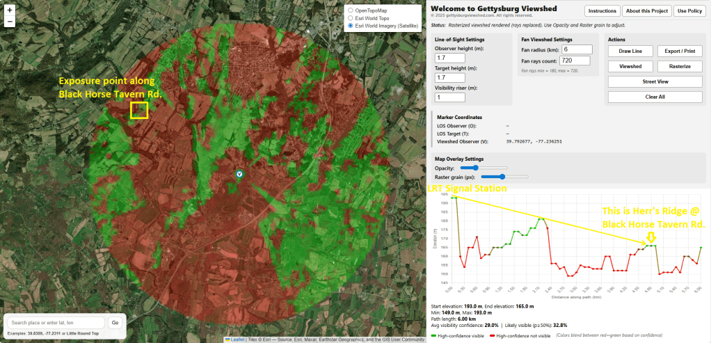
To complement the investigative spirit of So Nobly Advanced, I’ve developed an interactive mapping tool called Gettysburg Viewshed. The application is designed to help users explore how terrain influences visibility across the Gettysburg battlefield (or anywhere actually). It combines publicly available elevation data with geometric and probabilistic modeling to estimate what could plausibly be seen from specific locations.
Rather than presenting definitive conclusions, the tool encourages thoughtful engagement with ridges, slopes, and high ground while openly acknowledging uncertainty. Modern digital elevation models capture major features like Cemetery Ridge, Culp’s Hill, and the Round Tops with reasonable reliability. However, smaller topographical details (such as those within a thirty-meter grid cell) may be smoothed or unresolved. The model reflects ground height and does not presently include trees or buildings that existed in 1863. To address these limits, the application samples many points along each line-of-sight and uses Monte Carlo simulation to produce probability or confidence gradients. The intent is to make complex spatial analysis approachable for educators, students, and battlefield enthusiasts.
Readers of this blog may find the tool useful when following along with articles that discuss troop movement and observation. Some suggested investigations include:
- Examining whether Little Round Top had visibility toward Herr Ridge during Longstreet’s countermarch,
- Evaluating reciprocal visibility between Benner’s Hill and Powers Hill artillery positions, or
- Exploring the persistent question of whether the Peach Orchard truly offered “better ground” for the Third Corps on July 2, 1863…..
The application is built entirely with open-source libraries and publicly accessible data sources, requiring no proprietary datasets.
If you’d like to experiment with the landscape yourself, you can access the application at https://gettysburgviewshed.com.
I hope it serves as a helpful companion to the stories and sources presented here at So Nobly Advanced. Above all, may it encourage new questions about how the hills of Gettysburg (and/or other battlefields!) shaped what was known, what was seen, and how the battle ultimately unfolded.